


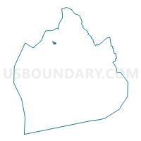
Voting District 5700049, Kings County, New York
About
Outline

Summary
| Unique Area Identifier | 628640 |
| Name | Voting District 5700049 |
| County | Kings County |
| State | New York |
| Area (square miles) | 0.04 |
| Land Area (square miles) | 0.04 |
| Water Area (square miles) | 0.00 |
| % of Land Area | 100.00 |
| % of Water Area | 0.00 |
| Latitude of the Internal Point | 40.68660440 |
| Longtitude of the Internal Point | -73.97737750 |
Maps

Graphs
Select a template below for downloading or customizing gragh for Voting District 5700049, Kings County, New York


Neighbors
Neighoring Voting District (by Name) Neighboring Voting District on the Map
- Voting District 5200066, Kings County, NY
- Voting District 5700048, Kings County, NY
- Voting District 5700063, Kings County, NY
- Voting District 5700091, Kings County, NY
- Voting District 5700093, Kings County, NY
- Voting District 5700094, Kings County, NY
- Voting District 5700095, Kings County, NY
Top 10 Neighboring County Subdivision (by Population) Neighboring County Subdivision on the Map
Top 10 Neighboring Place (by Population) Neighboring Place on the Map
Top 10 Neighboring Unified School District (by Population) Neighboring Unified School District on the Map
Top 10 Neighboring State Legislative District Lower Chamber (by Population) Neighboring State Legislative District Lower Chamber on the Map
Top 10 Neighboring State Legislative District Upper Chamber (by Population) Neighboring State Legislative District Upper Chamber on the Map
Top 10 Neighboring 111th Congressional District (by Population) Neighboring 111th Congressional District on the Map
Top 10 Neighboring Census Tract (by Population) Neighboring Census Tract on the Map
- Census Tract 181, Kings County, NY (3,936)
- Census Tract 179, Kings County, NY (3,624)
- Census Tract 33, Kings County, NY (2,327)
- Census Tract 39, Kings County, NY (2,229)
- Census Tract 129.01, Kings County, NY (2,159)
- Census Tract 35, Kings County, NY (1,554)
- Census Tract 37, Kings County, NY (390)